Mud Lake
Overview
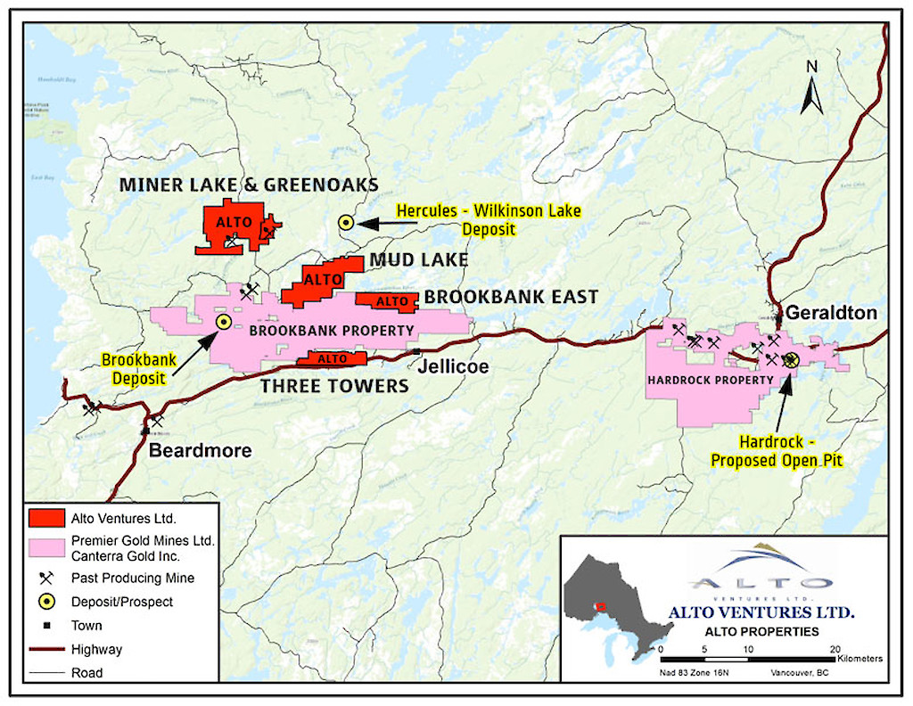
Ownership & Size: Big Ridge (formerly Alto)-100%
182 mining cell and boundary cell claims covering approximately 2,600 haStage: Early Stage: This project is available for a joint venture Gold Mineralization was discovered along a six km segment of the Mud Lake Shear Zone (MLSZ). To date 12 significant gold occurrences have been identified on surface by hydraulic washing and sampling. In 2007 and 2008 Alto completed 42 diamond drill holes totaling 3,045 m at several locations along the MLSZ. Surface glacial till sampling programs were completed during the 2018 and 2019 summer field programs returning several samples with significant gold grain counts in the tills.
Location & Infrastructure Located 25 km northeast of the Town of Beardmore. Year-round access via Trans-Canada Highway 17 and direct property access from the all-weather 801 Road.
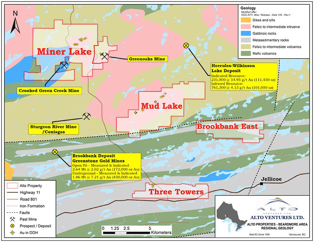
Regional Significance The property lies in the southern part of the Onaman Toshota greenstone belt which formed part of the previously producing Beardmore-Geraldton gold belt. Past production in the belt exceeded 4 million ounces of gold.
The Brookbank deposit, which is located 10 km southwest of Mud Lake is reported to contain over 600,000 ounces of gold. The Hercules deposit is located approximately 5 km north of Mud Lake and it hosts NI 43-101 compliant resources of 231,000 tonnes averaging 14.95 g/t Au Indicated and 761,000 tonnes averaging 4.13 g/t Au Inferred.
In Geraldton, approximately 50 km east of Mud Lake the Hardrock Mine Project is proceeding to the construction phase. Production of 4.2 million ounces of gold is anticipated from an open pit averaging 1.02 g/t Au over the next 15 years. Additional underground resources include 1.7 million ounces averaging 3.9 g/t Au. (Source: Premier Gold Mines Website)
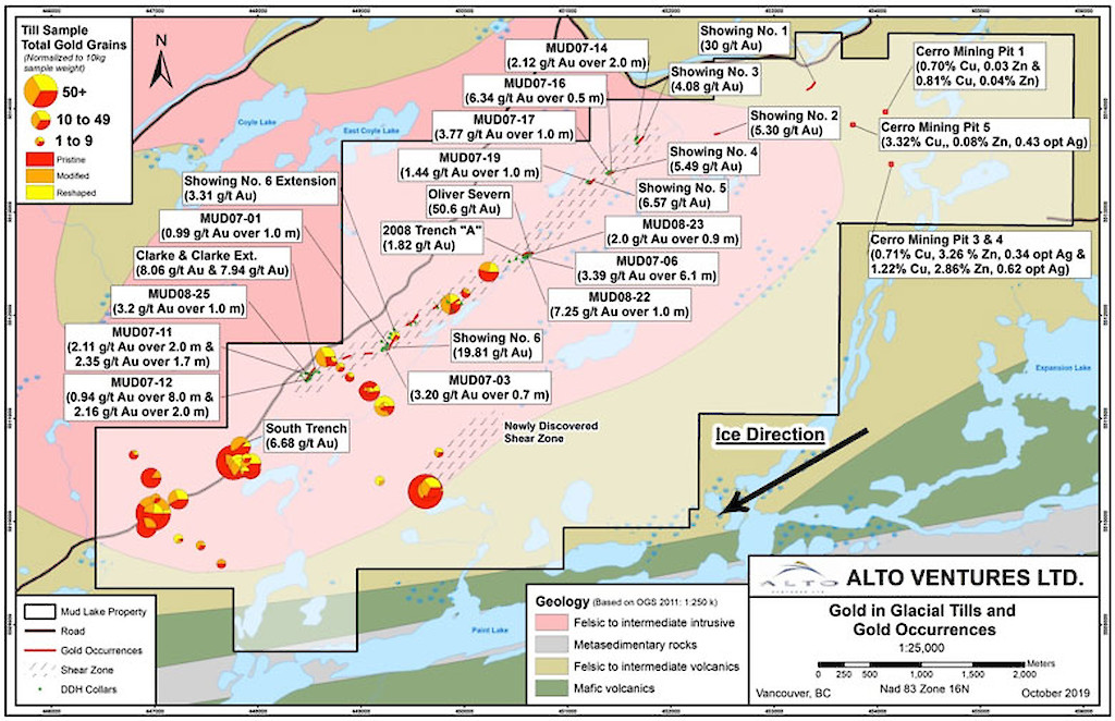
Project Summary - Gold mineralization occurs within shear-parallel quartz veins associated with the major, northeast trending MLSZ
- The MLSZ traverses through the Coyle Lake granodiorite to tonalite intrusive stock, and it has been traced for over six km on the property
- 12 significant gold occurrences have been found to date in proximity to the MLSZ
- Some of the better results from grab samples include:
30.0 g/t Au from Showing #1
50.6 g/t Au from Oliver Severn Showing
19.8 g/t Au from Showing #6
8.1 g/t Au from Clarke Showing
3.0 g/t Au across 1.0m saw cut channel sample from Showing #6 - Highlights from diamond drilling (Table 1) include:
13.9 g/t Au over 1m within a mineralized section of the MLSZ averaging 3.4 g/t Au over 6.1m
Table 1: Mud Lake Drilling Summary
Hole Name
From (m)
To (m)
Width (m)
g/Au/tonne
Occurrence
MUD07-01
15.1
16.1
1.0
0.99
Showing #6
MUD07-03
15.3
16.0
0.7
3.2
Showing #6
MUD07-06
Includes
12.3
14.9
17.4
28.6
18.4
15.4
18.4
29.6
6.1
0.5
1.0
1.0
3.4
9.64
13.9
5.5
Oliver Severn Z1
Oliver Severn Z2
MUD07-11
26.5
51.5
28.5
53.2
2.0
1.7
2.11
2.35
Clarke Zone 1
Clarke Zone 2
MUD07-12
Includes
80.0
82.8
88.8
84.8
8.0
2.0
0.94
2.16
Clarke
MUD07-14
19.0
21.0
2.0
2.12
Showing #3
MUD07-16
21.1
21.6
0.5
6.34
Showing #4
MUD07-17
23.7
24.7
1.0
3.77
Showing #4
MUD07-19
61.3
62.3
1.0
1.44
Showing #5
MUD08-22
36.6
37.6
1.0
7.25
Oliver Severn
MUD08-23
23.8
24.7
0.9
2.0
Oliver Severn
MUD08-24
19.0
21.0
2.0
1.21
Clarke Showing
MUD08-25
42.5
43.5
1.0
3.2
Clarke Showing
*The widths reported are down-hole lengths as there is insufficient drilling density to determine the true widths. Mineralized zones generally start at 0.1 g/t gold and assay averages may include minimal intervals of waste material. No top cuts of assays were used.
- Surface glacial till sampling in 2018 and 2019 down-ice from the MLSZ and from a newly discovered shear located east of the MLSZ returned several samples containing high gold grain counts, including one sample that had 429 gold grains
Outlook
Limited exploration by Alto has confirmed the persistence of gold mineralization along a six km segment a large shear zone that has been partially explored to shallow depths over sporadic sections of the shear zone. The glacial till sampling points to possible gold mineralization in sections of the MLSZ not yet prospected or drilled. The till survey also points to possible gold mineralization along the shear that was discovered in 2019 trending parallel to the MLSZ. Future exploration work includes further prospecting and rock sampling along the MLSZ and the newly discovered shear zone. Diamond drilling is dependent on further sampling and survey results.
Maps