Miner Lake
Overview
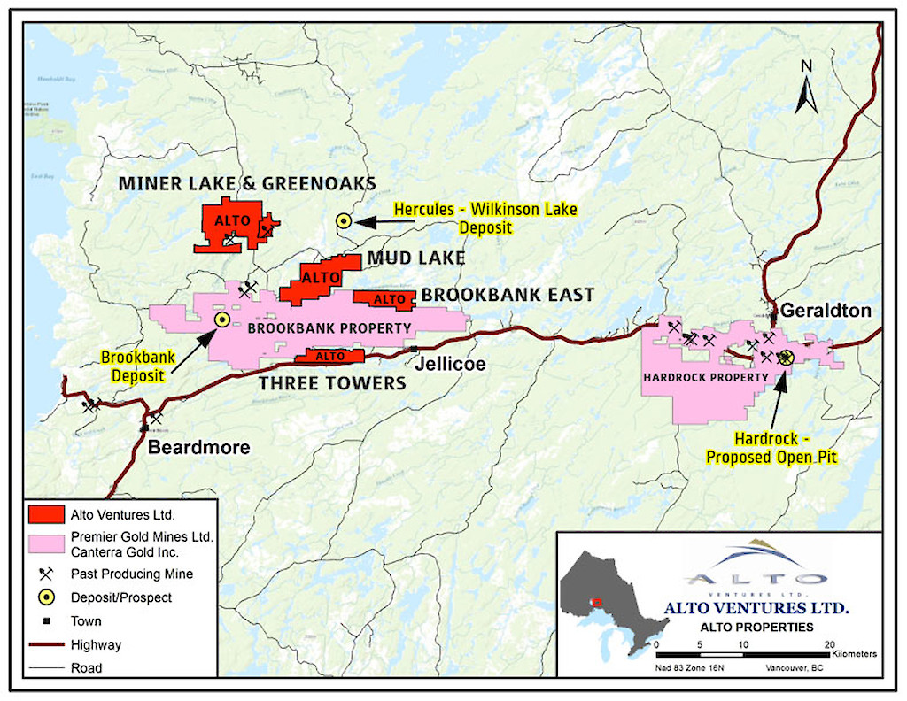
Ownership & Size: Big Ridge (formerly Alto)-100%
226 Claims Cells and Boundary Claim Cells totaling 3,328 HaStage: Early-stage: The property hosts a multitude of gold occurrences associated with hydrothermally altered and sheared breccia zones within intermediate intrusive rocks. As currently known, the intrusive body hosting the various breccia zones has surface dimensions of 2.5 km by 1.5 km.
Alto completed extensive surface stripping and sampling programs in the period from 2009 to 2011 and diamond drilling in 2011 and 2018. In aggregate 2,737 m of drilling was completed in 14 drill holes. Significant gold results were obtained from these surface and drilling programs.
Location & Infrastructure Pifher Township, 45 km northeast of the Town of Beardmore. Year-round access via Trans-Canada Highway 17 and direct property access from the all-weather 801 Road which passes through the property.
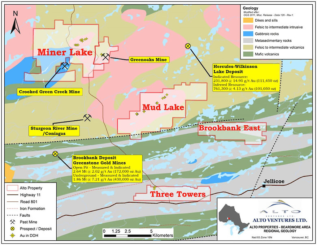
Regional Significance The property lies in the southern part of the Onaman Toshota greenstone belt which formed part of the previously producing Beardmore-Geraldton gold belt. Past production in the belt exceeded 4 million ounces of gold.
The Brookbank deposit, which is located 10 km south of Miner Lake is reported to contain over 600,000 ounces of gold. The Hercules deposit located approximately 10 km east of Miner Lake hosts a NI 43-101 compliant Indicated resource of 231,000 tonnes averaging 14.95 g/t Au and an Inferred resource of 761,000 tonnes averaging 4.13 g/t Au.
In Geraldton, approximately 50 km east of Miner Lake, the Hardrock Mine Project is proceeding to the construction phase. Production of 4.2 million ounces of gold is anticipated from an open pit averaging 1.02 g/t Au over the next 15 years. Additional underground resources include 1.7 million ounces averaging 3.9 g/t Au. (Source: Premier Gold Mines Website)
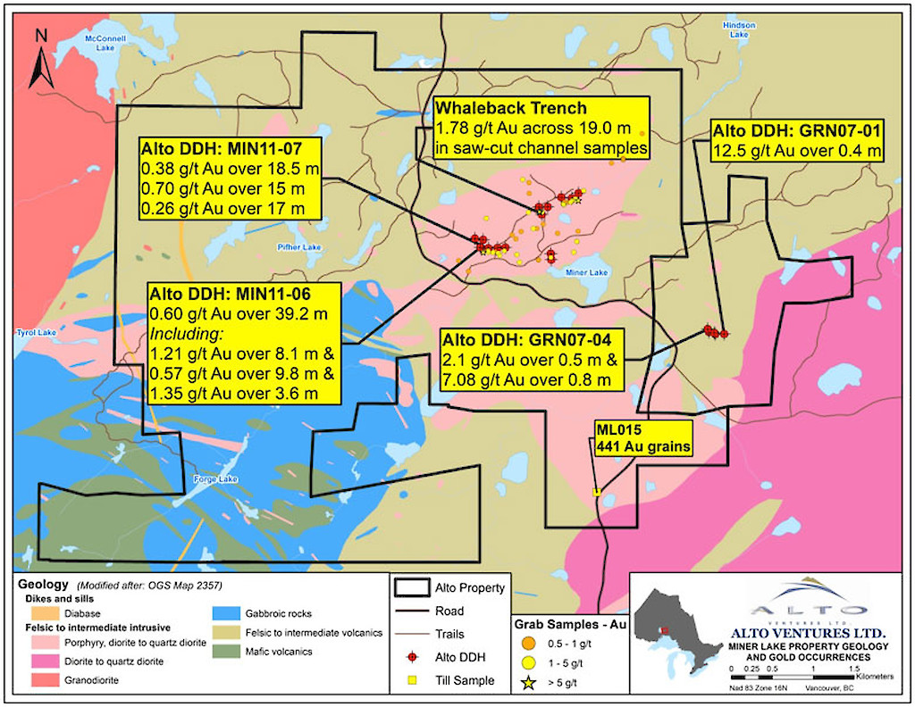
Project Summary - Gold is associated with a series of hydrothermally altered and locally sheared breccia zones hosted within granodiotite to porphyrytic diorite
- Mineralized zones are locally sulphide bearing, from 1% to 5% total sulphides, mainly pyrrhotite, chalcopyrite, pyrite
- Surface grab and saw-cut channel sampling returned numerous areas of anomalous gold.
- At the Whaleback Trench (See Map 3) a series of saw-cut channel samples averaged 1.78 g/t Au and 0.11% Cu over an aggregate width of 19 m
- Highlights of gold values in saw cut channel samples from some the other gold occurrences include:
2796 ppb Au, 149 ppm Cu over 1.0 m (Broken Arrow)
1055 ppb Au, 406 ppm Cu over 1.0 m (Broken Arrow)
1809 ppb Au, 284 pm Cu over 1.0 m (Artois Trench)
1285 ppb Au, 198 ppm Cu over 1.0 m (Roadside Trench)
1153 ppb Au, 420 ppm Cu over 1.0 m (Roadside Trench)
1259 ppb Au, 2020 ppm Cu over 1.0 m (Musketeer Trench)
1550 ppb Au, 619 ppm Cu over 1.0 m (Trench 37)
1141 ppb Au, 202 ppm Cu over 1.0 m (Trench 41)
1140 ppb Au, 279 ppm Cu over 1.0 m (Trench 41)
1977 ppb Au, 340 ppm Cu over 1.0 m (Trench 42)
1025 ppb Au, 16415 ppm Cu over 1.0 m (Trench 42) - Drilling to date (14 holes in total) has only tested a few of these breccia zones and anomalous amounts of gold were obtained from most of the drill holes. (Table 1)
Table 1: Alto drill results
Hole Name
From (m)
To (m)
Width (m)
g/Au/tonne
MIN11-02
130.1
141.75
11.65
0.19
MIN11-05
132.0
151.65
19.65
0.31
MIN11-06
includes
9.8
13.4
87.5
49.0
14.9
98.0
39.2
1.5
10.5
0.60
4.24
0.38
MIN11-07
9.0
32.5
77.0
27.5
47.5
94
18.5
15.0
17.0
0.38
0.70
0.26
MIN11-08
77.2
89.0
11.8
0.38
MIN18-10
160.5
175.5
15.0
0.48
MIN18-11
183.6
194.1
10.5
0.36
Min18-14
117.5
139.5
22.0
0.23
*The widths reported are down-hole lengths as there is insufficient drilling density to determine the true widths. Mineralized zones generally start at 0.1 g/t gold and assay averages may include minimal intervals of waste material. No top cuts of assays were used.
- Exploration model invokes large tonnage lower grade open-pit mineable mineralization, possibly Archean porphyry style
Outlook
Potentially large-tonnage drill-ready target with several breccia zones ready to be tested by diamond drilling. In addition, petrographic and geochemical alteration studies are recommended to confirm if the postulated porphyry target model applies. Induced Polarization and Resistivity geophysical surveys are recommended to find areas of higher sulphide concentrations and correlate the geophysical results with the drill and alteration studies to determine if increased sulphide content results in increased gold values.
Latest Update
November, 2018
A diamond drilling program comprising 1,010m in five holes was completed to further test the main East-West mineralized corridor as well as other targets on the property. Chlorite altered gold-bearing breccia zones associated with feldspar porphyritic diorite were intersected in each of the 2018 holes, with gold values ranging from under 0.002 g/t to 4.48 g/t/ Au in individual samples. The persistent and widespread distribution of gold in the numerous breccia zones in feldspar porphyritic diorite has confirmed the presence of a large gold mineralizing system on the property. Gold mineralization continues to be intersected and further drilling is required.
Maps